This page provides a comprehensive overview of four key weather resources for aviation and general weather enthusiasts. It includes an Aviation Weather Decode Card for interpreting aviation weather reports, insights into the Bureau of Meteorology’s forecasts and warnings, an introduction to Windy’s real-time weather visualization tool, and details about Meteoblue’s interactive weather maps. Ideal for pilots, mariners, and anyone needing accurate weather information for planning and safety.
Weather plays a crucial role in drone operations because it directly affects flight safety and performance. Factors like wind speed, temperature, precipitation, and visibility can impact a drone’s stability, battery life, and sensor accuracy. Strong winds can make controlling the drone difficult, rain can damage electronics, and poor visibility affects navigation and obstacle avoidance. Understanding weather conditions helps operators plan flights, avoid hazards, and ensure successful and safe drone missions.
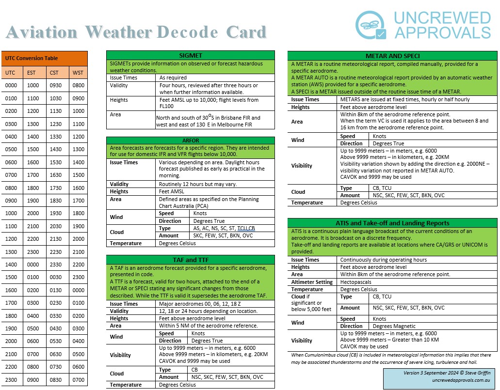
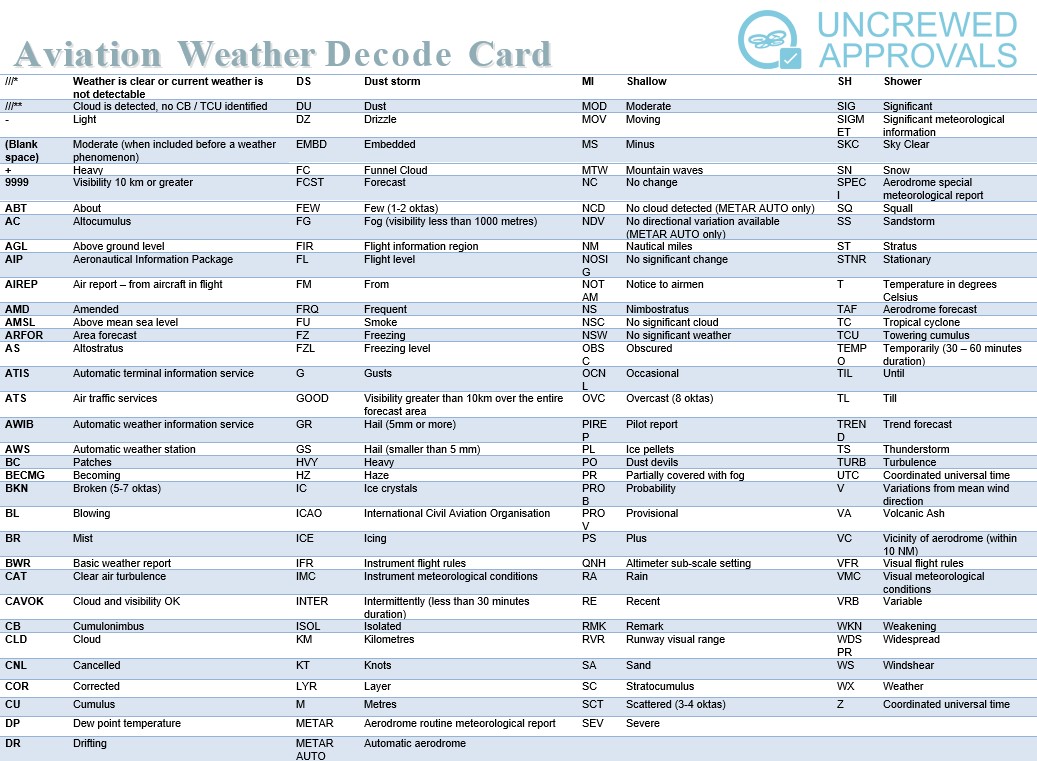
Aviation Weather Decode Card
This Aviation Weather Decode Card provides a comprehensive guide to interpreting aviation weather reports, forecasts, and terminology. It includes a UTC conversion table, details on various weather products like SIGMET, ARFOR, TAF, TTF, METAR, SPECI, and ATIS, and explanations of weather symbols, abbreviations, and terms used in aviation meteorology. It serves as a quick reference for pilots and aviation professionals to understand weather conditions, forecasts, and alerts for safe flight operations. Weather Decoder Download.
Bureau Of Meteorology
Bureau Of Meteorology provides a wide range of services including weather forecasts, severe weather warnings, radar and satellite imagery, climate information, and oceanographic data.
Key features and services:
-
Weather Forecasts:
-
Offers detailed weather forecasts for different regions, states, and major cities across Australia, including temperature, rainfall, wind, and humidity.
-
-
Warnings and Alerts:
-
Provides up-to-date alerts for severe weather events like thunderstorms, cyclones, floods, bushfires, and heatwaves. These warnings are essential for public safety and planning.
-
-
Radar and Satellite Imagery:
-
Offers real-time radar and satellite images showing rainfall, cloud cover, and other meteorological data, which is useful for tracking weather patterns.
-
-
Marine and Ocean Services:
-
Includes tide predictions, wave heights, and marine forecasts, helping those involved in marine activities, such as boating or fishing.
-
-
Climate and Water Data:
-
Provides long-term climate data, water storage information, drought reports, and climate outlooks for Australia.
-
-
Educational Resources:
-
Offers a variety of educational resources about weather, climate, and how BOM collects and processes its data.
-
It’s a comprehensive resource for weather and climate information in Australia and is widely used by the public, businesses, and government agencies for planning and decision-making.
Windy
Windy is an interactive weather visualization tool that provides detailed real-time weather data for various parameters. The link you provided specifically focuses on wave data, which is helpful for marine activities like sailing, fishing, or surfing. Here’s a breakdown of its features:
Key features and services:
-
Wave Information:
-
The page displays real-time data about wave height, direction, and period across different regions. You can see how the waves are moving and their intensity, making it a valuable resource for mariners.
-
-
Interactive Map:
-
The map is highly interactive, allowing users to zoom in and out, click on different areas, and explore wave conditions in any location worldwide. The map can also be adjusted to view other weather parameters.
-
-
Weather Layers:
-
Apart from wave data, Windy offers layers for wind, temperature, precipitation, cloud cover, pressure, and more. You can easily switch between these layers to get a comprehensive understanding of the weather.
-
-
Forecast Models:
-
Windy pulls data from various forecast models like ECMWF, GFS, ICON, and NAM, providing users with reliable and up-to-date forecasts.
-
-
Customizable Views:
-
Users can customize the display to show information relevant to their needs, such as changing the units for wave height or adjusting the map’s appearance.
-
Benefits:
- Marine Activities:
- The wave information is particularly valuable for those engaged in marine activities, such as surfers, sailors, fishermen, and even shipping companies, as it helps plan trips based on sea conditions.
- Weather Planning:
- The comprehensive weather data makes Windy useful for anyone looking to understand weather patterns, whether for outdoor activities or safety planning.
Windy is a powerful tool for visualizing complex weather data in an easy-to-understand format, and it’s widely regarded for its accuracy and user-friendly interface.
Meteoblue
The website Meteoblue is a weather forecasting service that offers a wide range of weather data and interactive maps for various parameters. The link you provided directs to the wind animation map, showing wind patterns and speeds at 10 meters above ground. Here’s a detailed overview of the key features and services of Meteoblue:
Key features and benifits:
-
Interactive Weather Maps:
- The page provides an interactive weather map that visualizes wind patterns across the globe. The map shows wind direction, speed, and intensity through an animated overlay, allowing users to see how wind flows in real time or in forecasts.
- You can explore different geographical locations by zooming in and out or panning around the map.
-
Multiple Weather Layers:
- Meteoblue offers a variety of weather layers that can be toggled on or off, such as temperature, precipitation, cloud cover, pressure, humidity, and even specialized parameters like air quality or snow cover.
- These layers allow users to customize the map to suit their specific interests, whether it’s for wind patterns, precipitation, or other weather data.
-
Forecast Models:
- Meteoblue uses different weather forecast models, providing a range of options for users. This includes long-term forecasts, short-term predictions, and even historical weather data.
- Forecasts can be viewed hourly or for longer periods, making it versatile for different planning needs.
-
Wind Animation:
- The wind animation feature visualizes wind speed and direction in a dynamic and colorful way. The rainbow color scheme indicates varying wind speeds, with different colors representing different intensities.
- The display of wind at “10 m above ground” is particularly useful for activities like agriculture, construction, aviation, and outdoor events.
-
Additional Tools and Data:
- Meteoblue provides access to detailed weather charts, radar images, climate data, meteograms, and air quality information. These can be especially helpful for understanding broader weather trends.
- Users can switch to other types of maps, such as cloud cover, temperature, or precipitation, to get a more comprehensive view of weather conditions.
Benefits:
- Planning and Decision-Making: The detailed wind data is useful for a wide range of activities, including aviation, agriculture, construction, marine activities, and sports like sailing or paragliding.
- User-Friendly Interface: The website is designed to be accessible, with easy-to-understand animations and clear data visualization, making it suitable for both weather enthusiasts and professionals.
Meteoblue is a robust platform for weather forecasting, offering high-quality data with various interactive tools that cater to different needs, whether for daily weather checks, travel planning, or professional weather monitoring.