Australian Airspace Classification
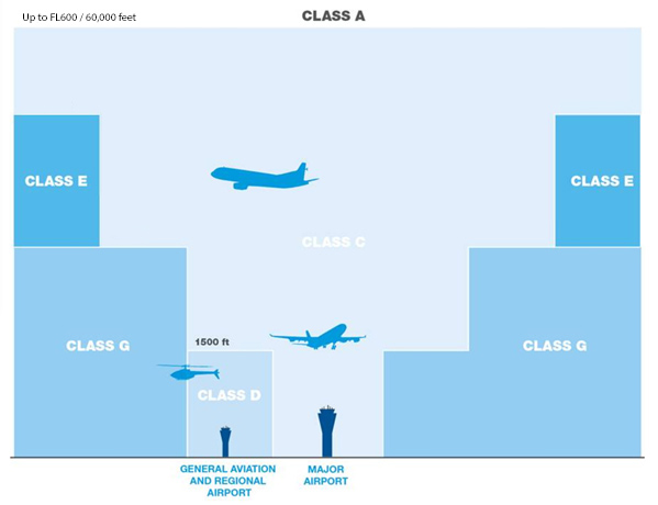
Australia uses five of the ICAO standard airspace classes (A, C, D, E, and G). The classes of airspace differ in that they have different operational requirements and / or operational restrictions. All of the Classes of airspace, except Class G, are controlled airspace.
Most RPAS / Drone operations are conducted in Class G ( General / Uncontrolled ). Operations can be conducted in Class C and D airspace if special procedures are followed.
Airspace Class Descriptions
Class A
Class A is high-level enroute airspace used by high-performance jet and turbo-prop airspace. VFR flights are not generally permitted within Class A airspace. It is very rare for RPAS / Drone operations to take place in Class A airspace. Separation is provided between all aircraft operating in Class A, with no speed restrictions. Clearance is required by all aircraft operating in Class A.
Class C
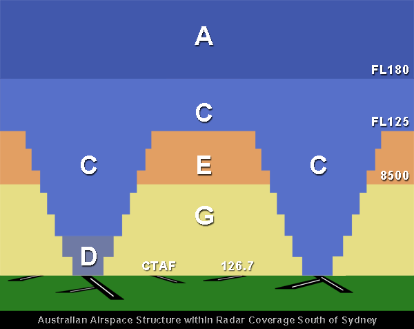
Class C surrounds major city airports starting at ground level and stepping up into mid-level Class C or the high-level Class A airspace. The control area steps above Class D aerodromes is also classified as Class C as airspace within radar coverage south of Sydney between FL125 and FL180. Military-restricted areas at or below FL285 are classified as Class C while they are active.
IFR and VFR flights are permitted within Class C, and VFR flights are limited to 250 kts indicated airspeed below 10,000 feet AMSL. (If you are a drone pilot, this is unlikely to be an issue for you). Air traffic services are required to separate IFR and IFR and IFR and VFR traffic. Traffic information and avoidance advice is provided for VFR to VFR traffic but a separation service is not. Clearance is required by all manned aircraft operating in Class C.
Uncrewed aircraft operating within 3NM of the aerodrome measurement points or above 400 feet above ground level (AGL) or within the defined approach path must have prior approval before flying in Class C. Within Class C, outside of 3NM of the aerodrome boundary and below 400 feet AGL, the operator should maintain a listening watch on a VHF radio.
Class D
Class D airspace is used around the non-capital controlled aerodromes. Protected airspace in Class C steps are provided above Class D to allow larger aircraft to remain inside controlled airspace while arriving and departing Class D.
IFR and VFR flights are permitted within Class D. Non-military IFR and VFR aircraft are limited to 250 kts indicated airspeed below 10,000 feet AMSL. Traffic information is provided to IFR about VFR traffic, and VFR flights receive information about all flights. Clearance is required by all crewed aircraft operating in Class D.
Class E
Class E is mid-level airspace where IFR aircraft are provided with a separation service from other IFR aircraft. Where controller workload permits, IFR aircraft to be given traffic information about known VFR traffic. VFR traffic only receives a flight information service on request. IFR and VFR flights are restricted to 250kts indicated airspeed below 10,000 feet AMSL. In Class E airspace, IFR aircraft must obtain a clearance, but VFR flights do not require a clearance.
Class G
Class G is uncontrolled airspace and accounts for the majority of Australian airspace. It is the only class of uncontrolled airspace. No separation service is provided to any aircraft operating in Class G. A flight and radar information service is provided to IFR traffic. A flight following service is provided to VFR flights on request. Within Class G, speed is restricted to below 250 kts for all aircraft below 10,000 feet AMSL.
Class G is the only airspace category in which ‘no radio’ flights may be conducted, but these are restricted to below 5,000 feet AMSL, away from airports that require the use of radio and in weather conditions than meet the standard VMC criteria.
Within Class G, some aerodromes operate a Common Traffic Advisory Frequency (CTAF), which imposes a requirement for radio to be carried and used. This does not affect the operational services or requirements provided by air traffic services.
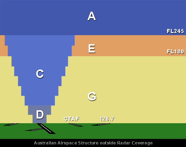
Airspace Design Models
There are three general airspace design models used in Australia. There is one for use in the majority of the country where there is no radar coverage. The other two are used along the east and southeast fringes of the country where there is radar coverage.
Different models are used in the north and south of Sydney because of the differing types of air traffic in those areas. From Sydney north, because of the more considerable distances that are generally flown, there are comparatively few high-performance piston engine aircraft used for commuter Regular Public Transport (RPT) operations. As a result, there is less traffic operating in the 8,000 – 10,000 foot altitude range. This means there isn’t sufficient demand for separation services between instrument flight rules (IFR) and visual flight rules (VFR) traffic to warrant Class C airspace below the flight levels. In the southern part of Australia, there are still many short-haul commuter aircraft operating between 8,000 and 10,000 feet, so Class C is provided.

Airspace Depiction on Charts
Airspace categories and their lateral and vertical limits are depicted on ERC-L, ERC-H, TAC VTC, and VNC charts. Each chart has a legend that gives specific information about how information is shown on the chart.
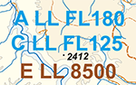 The lower limits of airspace are shown on all charts by indicating the airspace class and the lower limit. Where a piece of airspace commences at the surface, the lower limit is shown as ‘SFC.’ In areas where different classes of airspace are stacked vertically, the labels are shown in layers.
Class A, C, and D controlled airspace boundaries are shown on charts as a SOLID BLUE line. Class E controlled airspace is shown on charts as a SOLID BROWN line and should not be confused with the dashed brown flight information area frequency boundary. Military-controlled airspace and restricted areas are shown using MAGENTA lines.
Additional Information
Airservices Australia has information about operating drones in controlled airspace on their website.
CASA also has educational material on their Know Your Drone – Drone Rules page.